Returned to lender The Met accepts temporary loans of art both for short-term exhibitions and for long-term display in its galleries.
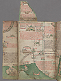
Map of the Holy Land, from Chronica majora, vol. I
Written and illustrated by Matthew Paris British
Not on view
The port of Acre, a principal arrival point for European Christian pilgrims, dominates this map of the Holy Land, created by an English monk, Matthew Paris. Other sites shown include the city of Tyre, famous for its glassware, in the lower left corner and Mount Ararat in Armenia, where Noah’s ark was believed to have landed, beneath the fold-up flap at the top left. The square, walled city of Jerusalem appears on the right page, with the Dome of the Rock, the Aqsa Mosque, and the Tomb of Jesus all highlighted. Matthew’s vividly detailed journey to Jerusalem was one of the imagination: an armchair traveler, he never ventured to the Holy Land.
Due to rights restrictions, this image cannot be enlarged, viewed at full screen, or downloaded.

This artwork is meant to be viewed from right to left. Scroll left to view more.
