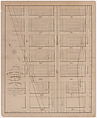
A Map of Property Lots between Leonard and Franklin Streets, Centre and Elm Streets, in New York
This cadastral (real estate survey) map contains two views of the same Manhattan site. At left is a plot bordered at left by Leonard Street, at right by Franklin Street, above by Elm Street and below by Centre Street. At right a second plan shows subdivisions.
Artwork Details
- Title: A Map of Property Lots between Leonard and Franklin Streets, Centre and Elm Streets, in New York
- Lithographer: Prosper Desobry (American, active New York, 1824–44)
- Date: ca. 1835
- Medium: Hand-colored lithograph
- Dimensions: Sheet: 10 15/16 × 17 1/8 in. (27.8 × 43.5 cm)
- Classification: Prints
- Credit Line: The Edward W. C. Arnold Collection of New York Prints, Maps and Pictures, Bequest of Edward W. C. Arnold, 1954
- Object Number: 54.90.1617
- Curatorial Department: Drawings and Prints
More Artwork
A slider containing 5 items.
Press the down key to skip to the last item.
Press the down key to skip to the last item.
Lithographer Prosper Desobry
1835
American
18th century

Robert Rauschenberg
1963
American
1800–1900

Publisher Issued by American Tobacco Company
1909–11
Research Resources
The Met provides unparalleled resources for research and welcomes an international community of students and scholars. The Met's Open Access API is where creators and researchers can connect to the The Met collection. Open Access data and public domain images are available for unrestricted commercial and noncommercial use without permission or fee.
To request images under copyright and other restrictions, please use this Image Request form.
Feedback
We continue to research and examine historical and cultural context for objects in The Met collection. If you have comments or questions about this object record, please contact us using the form below. The Museum looks forward to receiving your comments.