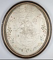
Embroidered map sampler
Not on view
Working an embroidered maps such as this sampler became part of a young girl’s education, starting in the 1770s, and continuing until about the 1840s. The map of England and Wales was so popular that printed versions were available to be stitched, which slightly reduces the potential for learning geography, while retaining the importance of practicing neat embroidery. The additional flourish of the floral garland is a charming feature. Other embroidered maps of geographical features were produced, from individual towns and counties, to the entire world in two hemispheres.
Due to rights restrictions, this image cannot be enlarged, viewed at full screen, or downloaded.

