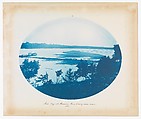
Mouth of Wisconsin River
With the goal of developing the Mississippi River into a secure transportation route, the United States Army Corps of Engineers hired Prussian-born cartographer Bosse to map the upper portion of the waterway between Minneapolis and St. Louis. Over the course
of ten years, he documented its meandering path under the dome of the Midwestern sky. His choice of the cyanotype—the same process used until recently by architects to duplicate their line drawings—was likely one of economy, as the materials were readily available to draftsmen. While many of his photographs document the interplay between the natural and the manmade, in this tranquil image, Bosse emphasizes sky and water, evoking the immensity and utter expansiveness of a subject that seems to have no bounds.
of ten years, he documented its meandering path under the dome of the Midwestern sky. His choice of the cyanotype—the same process used until recently by architects to duplicate their line drawings—was likely one of economy, as the materials were readily available to draftsmen. While many of his photographs document the interplay between the natural and the manmade, in this tranquil image, Bosse emphasizes sky and water, evoking the immensity and utter expansiveness of a subject that seems to have no bounds.
Artwork Details
- Title: Mouth of Wisconsin River
- Artist: Henry P. Bosse (American (born Germany), 1844–1893)
- Date: 1885
- Medium: Cyanotype
- Dimensions: Image: 10 9/16 × 13 1/2 in. (26.8 × 34.3 cm), oval
Sheet: 14 7/16 × 17 3/16 in. (36.7 × 43.7 cm) - Classification: Photographs
- Credit Line: Purchase, Acquisitions Fund and Mr. and Mrs. John A. Moran Gift, in memory of Louise Chisholm Moran, 2015
- Object Number: 2015.36
- Curatorial Department: Photographs
More Artwork
A slider containing 5 items.
Press the down key to skip to the last item.
Press the down key to skip to the last item.
Henry P. Bosse
1885
American
18th century
American
1901
Henry P. Bosse
1888
American
1830–35
Research Resources
The Met provides unparalleled resources for research and welcomes an international community of students and scholars. The Met's Open Access API is where creators and researchers can connect to the The Met collection. Open Access data and public domain images are available for unrestricted commercial and noncommercial use without permission or fee.
To request images under copyright and other restrictions, please use this Image Request form.
Feedback
We continue to research and examine historical and cultural context for objects in The Met collection. If you have comments or questions about this object record, please contact us using the form below. The Museum looks forward to receiving your comments.