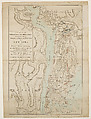
A Topographical Map of the North Part of New York Island, Exhibiting the Plan of Fort Washington, now Fort Knyphausen, with the Rebel Lines to the Southward
Artwork Details
- Title: A Topographical Map of the North Part of New York Island, Exhibiting the Plan of Fort Washington, now Fort Knyphausen, with the Rebel Lines to the Southward
- Artist: After Claude Joseph Sauthier (French, Strasbourg 1736–1802 Strasbourg)
- Publisher: William Faden the Younger (British, London 1749–1836 Shepperton)
- Date: March 1, 1777
- Medium: Hand-colored etching and engraving
- Dimensions: Plate: 18 7/8 × 10 7/8 in. (48 × 27.7 cm)
Sheet: 21 3/4 × 14 3/4 in. (55.2 × 37.5 cm) - Classification: Prints
- Credit Line: The Edward W. C. Arnold Collection of New York Prints, Maps and Pictures, Bequest of Edward W. C. Arnold, 1954
- Object Number: 54.90.1636
- Curatorial Department: Drawings and Prints
More Artwork
A slider containing 5 items.
Press the down key to skip to the last item.
Press the down key to skip to the last item.
Cartographer Claude Joseph Sauthier
Engraver William Faden the Younger
Publisher William Faden the Younger
February 25, 1777

labeled Richard Meares
ca. 1680

Rembrandt (Rembrandt van Rijn)
1658
William Faden the Younger
1776

Attributed to Barak Norman
1692
Research Resources
The Met provides unparalleled resources for research and welcomes an international community of students and scholars. The Met's Open Access API is where creators and researchers can connect to the The Met collection. Open Access data and public domain images are available for unrestricted commercial and noncommercial use without permission or fee.
To request images under copyright and other restrictions, please use this Image Request form.
Feedback
We continue to research and examine historical and cultural context for objects in The Met collection. If you have comments or questions about this object record, please contact us using the form below. The Museum looks forward to receiving your comments.