An Accurate Map of the Caribby [Caribbean] Islands, with the Crowns &c. to Which They Severally Belong, from the London Magazine
This is one of a series of maps that England's first literary periodical, the London Magazine, published during the Seven Years' War, a global conflict lasting from 1756-63. It documents Caribbean islands, from Santo Domingo and Puerto Rico at upper left, through the Leeward and Windward islands at right, and Lesser Antilles off South America. Prevailing trade winds are noted, reflecting research by astronomer Sir Edmond Halley and the navigator William Dampier. Many of the Lesser Antilles changed hands during this period with their colonial status decided at the Treaty of Paris which ended the war.
Artwork Details
- Title: An Accurate Map of the Caribby [Caribbean] Islands, with the Crowns &c. to Which They Severally Belong, from the London Magazine
- Engraver: Thomas Kitchin (British, Southwark 1719–1784 St. Albans)
- Printer: Robert Baldwin, London
- Date: 1759
- Medium: Etching and engraving
- Dimensions: Sheet (inlaid): 9 13/16 × 7 1/4 in. (25 × 18.4 cm)
Sheet: 10 1/2 × 9 1/2 in. (26.7 × 24.1 cm) - Classification: Prints
- Credit Line: Gift of Charles Allen Munn, 1924
- Object Number: 24.90.1199
- Curatorial Department: Drawings and Prints
More Artwork
A slider containing 5 items.
Press the down key to skip to the last item.
Press the down key to skip to the last item.
British
first half 18th century
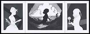
Kara Walker
Printer Gregory Burnet
2017
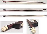
William Forster
1782
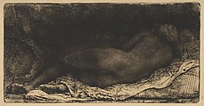
Rembrandt (Rembrandt van Rijn)
1658
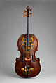
Joseph Bradbury
ca. 1700
Research Resources
The Met provides unparalleled resources for research and welcomes an international community of students and scholars. The Met's Open Access API is where creators and researchers can connect to the The Met collection. Open Access data and public domain images are available for unrestricted commercial and noncommercial use without permission or fee.
To request images under copyright and other restrictions, please use this Image Request form.
Feedback
We continue to research and examine historical and cultural context for objects in The Met collection. If you have comments or questions about this object record, please contact us using the form below. The Museum looks forward to receiving your comments.