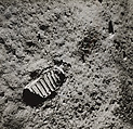
Day 322, Survey U, Sectors 15 and 16
Starting in 1966, NASA launched a series of unmanned expeditions called Surveyor that were intended to determine the character of the lunar terrain prior to the manned Apollo landings that began in 1969. During the Surveyor Missions, detailed topographic images (recorded by a tracking camera mounted to the lunar probe) were beamed to television monitors at the Jet Propulsion Laboratory in Pasadena, California. The images on the monitors were then photographed, and the photographic prints were assembled into mosaics by members of the USGS at JPL.
Artwork Details
- Title: Day 322, Survey U, Sectors 15 and 16
- Artist: United States Geological Survey (American)
- Artist: National Aeronautics and Space Administration (NASA)
- Date: 1967
- Medium: Instant diffusion transfer prints (Polaroid)
- Dimensions: 74.4 × 30.1 cm (29 5/16 × 11 7/8 in.)
- Classifications: Collages, Photographs
- Credit Line: Purchase, Nancy and Edwin Marks Gift, 1992
- Object Number: 1992.5153
- Curatorial Department: Photographs
More Artwork
A slider containing 5 items.
Press the down key to skip to the last item.
Press the down key to skip to the last item.
National Aeronautics and Space Administration (NASA)
1969
John Sloan
1907
Alan Kikuchi-Yngojo
1981
![[Panorama of Moon Surface, from Apollo 16 Mission], National Aeronautics and Space Administration (NASA) American, Gelatin silver print](https://images.metmuseum.org/CRDImages/ph/web-additional/DP134992.jpg)
National Aeronautics and Space Administration (NASA)
April 1972
Meta Overbeck
Louis C. Tiffany
Manufacturer Tiffany & Co.
ca. 1914–15
Related Content
Research Resources
The Met provides unparalleled resources for research and welcomes an international community of students and scholars. The Met's Open Access API is where creators and researchers can connect to the The Met collection. Open Access data and public domain images are available for unrestricted commercial and noncommercial use without permission or fee.
To request images under copyright and other restrictions, please use this Image Request form.
Feedback
We continue to research and examine historical and cultural context for objects in The Met collection. If you have comments or questions about this object record, please contact us using the form below. The Museum looks forward to receiving your comments.