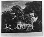
A South West View of the City of New York, in North America
Published in London in 1768, this prospect of New York was made when the city was under British control. Pierre Canot based his engraving on a drawing that Thomas Howdell, a Royal Artillery captain, made about 1763. The view looks south from a point near the present intersection of Henry and Montgomery Streets on the Lower East Side. The hill in the foreground was called Mount Pitt. At left is the East River, with Nutting (now Governor's Island) and Staten Island in the distance. The city appears at right. In 1765 New York's population had reached about 12,500 and streets were being laid out as far north as Collect Pond, a primary water source near what is today Foley Square. Beyond were pleasure gardens and burial grounds then estates, farms, and villages.
Artwork Details
- Title: A South West View of the City of New York, in North America
- Series/Portfolio: Scenographia Americana, or a Collection of Views in North America and the West Indies
- Engraver: Pierre Charles Canot (French, Paris 1710–1777 Kentish Town, London (active England))
- Artist: After Captain Thomas Howdell, of the Royal Artillery (British, active New York 1763)
- Publisher: John Bowles (British, 1701?–1779) London
- Publisher: Robert Sayer (British, Sunderland 1725–1794 Bath)
- Publisher: Thomas Jeffreys (British, ca. 1719–1771)
- Published in: London
- Date: ca. 1768
- Medium: Etching and engraving; probably second or third state
- Dimensions: plate: 14 1/8 x 20 1/2 in. (35.9 x 52.1 cm)
sheet: 17 11/16 x 24 3/16 in. (44.9 x 61.4 cm) - Classification: Prints
- Credit Line: Bequest of Charles Allen Munn, 1924
- Object Number: 24.90.42
- Curatorial Department: Drawings and Prints
More Artwork
A slider containing 5 items.
Press the down key to skip to the last item.
Press the down key to skip to the last item.
Engraver Pierre Charles Canot
After Jean Pillement
Publisher Esnauts et Rapilly
1759
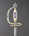
Goldsmith James Morisset
hallmarked for 1797–98

Gideon Saint
ca. 1760

Engraver Pierre Charles Canot
After Jean Pillement
Publisher Esnauts et Rapilly
1759
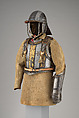
Armorer Armor attributed to Richard Holden
Armorer Helmet cheek pieces and metal plates on shoulder straps made by Daniel Tachaux
ca. 1683 and later; buff coat, 17th–18th century
Research Resources
The Met provides unparalleled resources for research and welcomes an international community of students and scholars. The Met's Open Access API is where creators and researchers can connect to the The Met collection. Open Access data and public domain images are available for unrestricted commercial and noncommercial use without permission or fee.
To request images under copyright and other restrictions, please use this Image Request form.
Feedback
We continue to research and examine historical and cultural context for objects in The Met collection. If you have comments or questions about this object record, please contact us using the form below. The Museum looks forward to receiving your comments.