
The Met's new digital-first map, launching today
«Helping visitors navigate The Met Fifth Avenue has long been a challenge at the Museum. In fact, it's a challenge woven into the architecture and history of the building itself, a collection of 20 interconnected structures built at various times since the institution first opened at its current location in 1880.»
We've seen digital as part of a potential solution for some time; the challenge, though, has been that to deliver a scalable and sustainable digital map—one that we can use across the website (desktop and mobile), The Met App, the Audio Guide, and on interactive signage—we first needed to rethink the Visitor Map itself.
Digital First
The printed Visitor Map is the cornerstone of the Museum's solution to wayfinding in the building. It is available to visitors as a free leaflet at all Museum entrances and throughout the building at information desks; each year, we distribute 3.5 million copies in 11 different languages.
On March 1, 2016, the Museum released an updated version of the Visitor Map. The new version is simpler, cleaner, and easier to use, and it represents a step forward in helping visitors understand and navigate the building. What was likely less apparent to visitors when the new map launched was the larger transformation it represents.

The Met's new Visitor Map, released in 11 languages on March 1, 2016
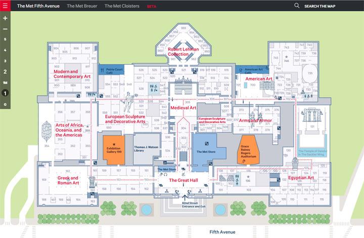
The new Visitor Map is in fact an analogue derivative of a powerful new digital map we've been working on in partnership with Applied Wayfinding and Living Map. As of March 1, the floor plans at The Met were born digital.
Today we've launched the public beta version of the "parent" digital map for The Met. We're one of the largest indoor sites to develop this type of tool, and though we're just at the start of its development, this is a key milestone in the Museum's journey toward a scalable and sustainable solution for indoor positioning and wayfinding.
It's a Dataset
One of the biggest obstacles we faced in rendering indoor maps on digital platforms in the past was that the foundational asset was the paper map. It was a flat graphic with a single level of zoom for which we had to develop a set of clever, but relatively brittle, manipulations to get it to meet basic user expectations of a digital map. It was this complexity that first made us decide not to include a map in The Met App.
The Museum's new digital map is first and foremost a dataset. We've mapped out the geocoordinates of every public space across our three locations, and to this dataset we've added information about the floor, unique ID, type, and title (and more) of each room.
The digital map you can now see online is dynamically rendered from that dataset. And because the map is dynamically rendered, we can manage the properties (and even languages) of each data point so that the type of information displayed on the map is appropriate to the context in which it is displayed. This means that, similar to Google Maps, there are a number of "zoom levels": when you view the building at the furthest zoom, the map shows you the thematic layout of our collection across the building, whereas when you zoom into the building, gallery numbers and facilities start to appear.
Achieving Scalability and Sustainability: A Locations API
At this stage, I should reiterate that the version of the digital map we've launched today is the public beta. It's a powerful tool with a lot of potential, but it's going to take some time for us to learn how to use it to its full potential and to integrate it into our various digital products successfully.
The launch version looks great on desktop, but there's work to be done for mobile. Also, all the data is hosted externally with Living Map's software, and the connections between the map and metmuseum.org and The Met App are yet to be sown; clicking on a gallery link on metmuseum.org does not currently take you to the same gallery on the digital map. That's obviously the plan, but we need to build this out in a manner that can be scaled from the website to the App, Audio Guide, and in-gallery signage too.
To achieve this in a sustainable and scalable manner, we're building a Locations API through which metmuseum.org, The Met App, and all our digital products will communicate with the digital map and through which the map will ingest up-to-date, location-related information about the Museum. And one day—if the Google and Apple gods are willing—we'd love to link that API to a floor plan of the Museum inside Google Maps and Apple Maps so that we can deliver a compelling and up-to-date user experience of the building to their large user bases.
We've also started prototyping how to map the native positioning technologies on the iPhone together with the geocoordinate data in the Locations API. If we can get that part right, it should set us on the path toward indoor positioning and wayfinding, and we're very excited about that.
Until then, though, we'd love to hear your feedback on the new digital map; please let us know your thoughts below.
Thank you to our colleagues at the American Museum of Natural History, MONA, Brooklyn Museum, and De Young Museum for their pioneering work and generous knowledge sharing on the development of locations services for museums; we build on their shoulders. Thank you too to Applied Wayfinding and the Living Map Company, our partners on this journey.