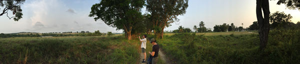
Conservator Ellen Howe and Alisa LaGamma, Ceil and Michael E. Pulitzer Curator in Charge of the Department of the Arts of Africa, Oceania, and the Americas, stand in the avenue of mango trees (Mangifera indica L.) that leads down to Loango Bay. Photograph by James Green
As part of the research for the exhibition Kongo: Power and Majesty, I traveled to the Loango coast region of the Republic of the Congo with Alisa LaGamma, Ceil and Michael E. Pulitzer Curator in Charge of the Department of the Arts of Africa, Oceania, and the Americas, and Conservator Ellen Howe in May 2015. We visited Loango Bay, where the transatlantic slave trade has been memorialized through the planting of an avenue of mango trees (Mangifera indica L.). Similar to Jo Ractliffe's approach in her photographs of Angola and South Africa, we looked at sites of conflict in the silence that exists afterwards.
A map depicting the Central African coastline and the "Kingdoms of Congo and Angola," first published in Amsterdam circa 1660, was reissued several times during the last quarter of the seventeenth century. The hand-colored example below dates from circa 1700. Turned counterclockwise so that the eastern axis is positioned due north, the map covers the coast from present day Port-Gentil in Gabon to Lobito in southern Angola, including the Loango region.

Gerard Valck and Petrus Pieter Schenck's map depicting "the Kingdoms of Congo and Angola." Copyright © Afriterra Foundation
While the land mass corresponds in major points with the actual shape of the coast, in knocking the African continent on its side, the cartographer has initiated a radical shift in the viewer's perspective. What becomes clear is that this map is less about Africa and more about how Europeans—particularly the Dutch—viewed this area of Africa and its people at the end of the seventeenth century.

In studying the map, the viewer must approach the African continent from the Atlantic Ocean as a Dutch seafaring trader of the late seventeenth century might have done. The information provided, concentrated along the coastline, includes the names of European commercial settlements and notable topographical features—such as headlands of rock, lagoons, and rivers—that were useful to a ship captain, both to mark his progress along the coast and secure a safe passage.
Left: A satellite view of the continent of Africa from a late-seventeenth-century Dutch perspective. Map data 2015 © Google
Elements of fantasy and reality merge in the enlarged and exaggeratedly fluid depictions of Central Africa's waterways. They are shown to extend easily into the continent itself, as if they were highways into the interior, there by the grace of God to facilitate easy trade.[1] The political borders of "Congo" and "Angola" are likewise overly simplified so that they resemble the borders of European nation states, showing that there was little knowledge of or interest in the multifarious and interconnected Kongo polities of this period, which included the kingdoms of Kongo, Loango, Kakongo, and Ngoyo.
The importance of the Atlantic Ocean is underscored by the fact that it takes up roughly a third of the space available on the map. The fantastical appears again in the blank space of the sea, where the cartographer has included the Roman gods Neptune and Juno, surrounded by a retinue of figures sporting in the water. While these joyful and procreative creatures of Western mythology serve a primarily decorative function, they also appear to support the passage of the two Dutch sailing ships also depicted in the ocean.
The last quarter of the seventeenth century was marked by an escalation in the trade of enslaved men and women across the Atlantic to work on European mines and agricultural plantations in the Americas. European manufactured goods in the form of cloth, glass beads, metal goods, and guns were exchanged in return. Portuguese merchants dominated this trade until they were outpaced by the Dutch, who, along with English and French slaving ships, were to remain the major slavers on the Loango coast through the late eighteenth century. In this context, we might imagine that the idealized sailing ships depicted on the Dutch map of the late seventeenth century are slaving ships.
Loango Bay was located about five miles from Buali, the capital of the Kingdom of Loango. It was a major trading port and point of access for foreign traders of the seventeenth century. As Phyllis Martin describes in the Kongo: Power and Majesty catalogue, "on arrival at Loango Bay, foreign traders were escorted to the royal capital . . . [where] . . . they might be granted an audience with the Maloango, or meet with royal officials to negotiate the terms of trade."[2]
An illustration that appears in the Dutch scholar-geographer Olfert Dapper's 1668 account Naukeurige Beschrijvinge der Afrikaensche Gewesten, below, gives us a sense of what this thriving and bustling centralized capital would have looked like in the mid-sixteenth century.

De Stadt van Loango (Plan of Buali, Capital of Loango) from Olfert Dapper's Naukeurige Beschrijvinge der Afrikaensche Gewesten
No traces of the historic capital of Buali remain today. Likewise, at Loango Bay, no structures remain that indicate the historical significance of this port. As Lydie Pongault, advisor to the minister of arts and culture of the Republic of the Congo, notes, "there are no material traces on the site. Nothing remains to tell us that this was a port where so many people were taken as slaves to the Americas. The site has to be commemorated, and quickly. There's erosion, the sea is slowly taking over."

Left: A view of Loango Bay looking towards Pointe Indienne, the southern end of Loango Bay. Right: Sunset over the Atlantic, in the direction of Brazil, as seen from Loango Bay. Photographs by James Green
Of the twelve to thirteen million slaves estimated to have been shipped from Africa between 1501 and 1866, forty-five percent are thought to have come from West Central Africa.[3] We do not know how many of these men and women passed through Loango Bay itself, but we might estimate hundreds of thousands. The only memorial to the lives that passed through here are a double rank of mango trees (Mangifera indica L.) said to mark the path trod by slaves on their final approach to the Atlantic.

Left: An avenue of mango trees lead to Loango Bay. Right: Detail of a mango tree. Photographs by James Green
Today, the trees stand one hundred feet (thirty meters) tall and, at this stature, may be three hundred years old. The avenue stretches along the crest of a hill and turns sharply down towards the Atlantic, so that it approaches the sea in a straight line that ends at sheer cliffs before the ocean.

Mango trees are a potent symbol of the slave trade, for the trees were first transported to West Africa in the cargo of Portuguese vessels of the fifteenth and sixteenth century from their original centers of domestication in India and Southeast Asia.[4] The earliest known illustration of a mango tree and its fruit from 1656 is contemporaneous with the escalation of the transatlantic slave trade from the Loango coast region.
Right: The earliest known illustration of a mango tree and fruit, from Michael Boym's Flora Sinensis: Frvctvs Floresqve Hvmillimi Porrigens
The arrival of the mango in Africa, and afterwards in Brazil, was part of a global trade in exotic fruits that included the pineapple, the banana, the guava, and the "nectarine and curious peach," to name a few examples.[5] Of all the fruits and flowers that began to be traded from the late fifteenth century onward, the seeds of a mango were one of the hardest to transport, for once desiccated they cannot grow. In order for them to survive, Portuguese navigators had to take with them the ripe fruit, seedlings, or, later, grafted plants.[6] Mangoes, in other words, had to be transported alive.
The graveyard of the Loango Catholic mission station borders this avenue of mango trees on its southern side. Planted closely together, the trees form an impressive wall of dark green foliage when seen from a distance.

Left: The avenue of mango trees bordering the graveyard of the Loango Catholic mission. Right: The avenue from another perspective. Photographs by James Green
Standing with Abbé Raphael Nzaou, the head of the mission station, we wondered aloud at the trees, and the Abbé offered us two traditions concerning their origin. In the first, he described how slaves, as they were marched to the coast, dropped mango seeds along the way that later grew into trees. The trees thus symbolized their final African meal before their departure across the Atlantic, which was understood as death. The second story recounted how those who were left behind planted a mango tree as a memorial to an individual life lost. He noted that, today, it was common practice to plant a tree on the grave site of a deceased individual, and showed us where this had been done in the graveyard.
We walked along the path from where the mango trees began on the crest of the hill. In some places, they stood in straight lines, and, in others, the trees disappeared into the tropical undergrowth and the path ceased to exist. The walk took us longer than we expected; we only arrived at the coastline as the sun was setting. Looking out at Loango Bay, it was unsettling to think that Diogo Cão, captain of the first European ship to travel this far south, first set anchor here in August 1483.[7]
Acknowledgements
I would like to sincerely thank Dr. Phyllis Martin, whose recommendations shaped our trip to the Republic of the Congo, and who recommended that we visit this site. We would also like to acknowledge the important work of Joseph Kimfoko Madoungou, curator of the Ma-Loango Regional Museum, based at Diosso near Loango Bay, in keeping these histories alive.
Notes
[1] This fantasy of the African river as a highway of commerce was to re-appear in European traveler's accounts of the mid-nineteenth century, as in missionary explorer David Livingstone's imagining of the Zambezi River in Missionary Travels and Researches in South Africa (London, Murray: 1857).
[2] Martin, Phyllis. Kongo: Power and Majesty. Metropolitan Museum of Art, New York: 2015, 58.
[3] Taken from The Trans-Atlantic Slave Trade Database estimates.
[4] In East Africa, mango trees are also found to mark the paths walked by slaves to the coast, where the fruit may have been introduced before the fifteenth century by Arab traders.
[5] Marvell, Andrew. "The Garden," in Andrew Marvell: The Complete Poems, edited by Elizabeth Story Donno. London: Penguin, 1972, 100–102.
[6] Litz, Richard E. The Mango: Botany, Production and Uses. Wallingford, UK: CAB International, 1997, 11.
[7] Ravenstein, E. G. The voyages of Diogo Cão and Bartholomeu Dias, 1482–88. London: W. Clowes and Sons, 1900, 5. According to Ravenstein, he named Loango Bay Praia Formosa de S. Domingos, suggesting that he may have arrived here on that saint's day, August 4, 1483.