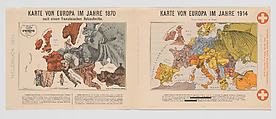
Karte von Europa im jahre 1870 / Karte von Europa im jahre 1914
Paul Hadol French
Walter Trier Bohemian
Printer Reklameverlag Ernst Marx German
Not on view
World War I poster.
Satirical maps comparing the political situations in Europe in the years 1870 and 1914. The left-hand map depicts the continent at the beginning of the Franco-Prussian War of 1870–71, designed by the Parisian artist, Paul Hadol. The map on the right, designed by German-Jewish artist, Walter Trier, shows Europe shortly after the outbreak of World War I.
This image cannot be enlarged, viewed at full screen, or downloaded.


