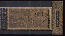
Map of the Grand Canal from Beijing to the Yangzi River
Managing China's complex network of rivers, canals, and irrigation systems has been one of the abiding concerns of its rulers. From the fourteenth century, the Grand Canal served as the major artery for transporting grain from the wealthy agricultural regions south of the Yangzi River to the capital city of Beijing in the north. Of equal importance was the constant threat of flooding from the Yellow River and other river systems that traversed the canal. Under the Manchu Qing dynasty (1644–1911), both the Kangxi (r. 1662–1722) and Qianlong (r. 1736–95) emperors personally inspected the hydraulic management measures in this region on their periodic tours of the empire.
This map follows the course of the Grand Canal from the vicinity of Beijing southward to the Yangzi River. Artistically, it stands halfway between modern cartographic records and the more pictorial approach to mapmaking that was commonly used prior to the twentieth century in China. While most elements are schematically rendered, images of the Forbidden City, the Yangzi River, and certain mountains and topographic features are treated in pictorial terms. All of the rivers, canals, dams, sluice gates, dikes, and catchment basins as well as the walled cities and important towns situated near the canal are depicted and labeled. The linchpin of the entire hydraulic system was the confluence of the Yellow and Huai Rivers with the Grand Canal. Based on documented changes to the configuration of the Huang-Huai confluence and other areas, the content of the map can be dated to the period from 1737 to 1761.
This map follows the course of the Grand Canal from the vicinity of Beijing southward to the Yangzi River. Artistically, it stands halfway between modern cartographic records and the more pictorial approach to mapmaking that was commonly used prior to the twentieth century in China. While most elements are schematically rendered, images of the Forbidden City, the Yangzi River, and certain mountains and topographic features are treated in pictorial terms. All of the rivers, canals, dams, sluice gates, dikes, and catchment basins as well as the walled cities and important towns situated near the canal are depicted and labeled. The linchpin of the entire hydraulic system was the confluence of the Yellow and Huai Rivers with the Grand Canal. Based on documented changes to the configuration of the Huang-Huai confluence and other areas, the content of the map can be dated to the period from 1737 to 1761.
Artwork Details
- 清 佚名 大運河地圖 (從北京至長江) 卷
- Title: Map of the Grand Canal from Beijing to the Yangzi River
- Artist: Unidentified artist (Chinese, late 18th or early 19th century)
- Period: Qing dynasty (1644–1911)
- Date: late 18th or early 19th century
- Culture: China
- Medium: Handscroll; ink and color on silk
- Dimensions: Image: 21 7/8 in. × 30 ft. 7 in. (55.6 × 932.2 cm)
Overall: H. 32 1/4 in. (81.9 cm) - Classification: Paintings
- Credit Line: Purchase, Friends of Asian Art Gifts, 2003
- Object Number: 2003.417
- Curatorial Department: Asian Art
More Artwork
A slider containing 5 items.
Press the down key to skip to the last item.
Press the down key to skip to the last item.
Unidentified artist
ca. 1340
Chinese
late 16th–early 17th century
Attributed to Qu Ding
ca. 1050
Unidentified artist
16th century
Chinese
1368–1644
Research Resources
The Met provides unparalleled resources for research and welcomes an international community of students and scholars. The Met's Open Access API is where creators and researchers can connect to the The Met collection. Open Access data and public domain images are available for unrestricted commercial and noncommercial use without permission or fee.
To request images under copyright and other restrictions, please use this Image Request form.
Feedback
We continue to research and examine historical and cultural context for objects in The Met collection. If you have comments or questions about this object record, please contact us using the form below. The Museum looks forward to receiving your comments.