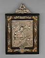
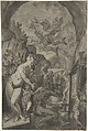
Belagerung Armentirs in Flandern (Siege of Armentirs (Armentières))
Now part of France and known better for the battle that took place there during World War I, the city of Armentières (Armentirs) was part of the Spanish Netherlands in the 16th century and became a much contested site during the Thirty Years War. Following its capitulation to the French in 1645, the city was reclaimed by Hapsburg forces, under the command of Archduke Leopold Wilhelm, then governor of the Spanish Netherlands, on May 30, 1647, in the siege depicted here. It would later, in a treaty of 1668, be ceded to France permanently. This fascinating cartographic representation, showing the precise positions of the various regiments, appeared in J. Georg Schleder's Theatrum Europaeum, published by Matthäus Merian in Frankfurt in 1663 (volume 6, between pages 154 and 155). The eagle at upper right (an imperial symbol) bears an escutcheon with the double-headed eagle of the Hapsburgs at its center.
Artwork Details
- Title: Belagerung Armentirs in Flandern (Siege of Armentirs (Armentières))
- Artist: Anonymous, German, 17th century
- Date: 1663
- Medium: Etching
- Dimensions: Sheet: 12 15/16 × 14 15/16 in. (32.8 × 37.9 cm)
Plate: 11 1/16 × 14 in. (28.1 × 35.6 cm)
Image: 11 in. × 13 7/8 in. (28 × 35.3 cm) - Classification: Prints
- Credit Line: Gift of Family Rosenthal, 2023
- Object Number: 2023.232.3
- Curatorial Department: Drawings and Prints
More Artwork
A slider containing 5 items.
Press the down key to skip to the last item.
Press the down key to skip to the last item.
Anonymous, German, 17th century
late 16th–early 17th century
Hercules Segers
ca. 1625–30
Anonymous, German, 17th century
Former Attribution Formerly attributed to Johann Matthias Kager
1614
James McNeill Whistler
1879–80
Anonymous, German, 17th century
Former Attribution Johann Matthias Kager
ca. 1605
Research Resources
The Met provides unparalleled resources for research and welcomes an international community of students and scholars. The Met's Open Access API is where creators and researchers can connect to the The Met collection. Open Access data and public domain images are available for unrestricted commercial and noncommercial use without permission or fee.
To request images under copyright and other restrictions, please use this Image Request form.
Feedback
We continue to research and examine historical and cultural context for objects in The Met collection. If you have comments or questions about this object record, please contact us using the form below. The Museum looks forward to receiving your comments.